The Location element is a map-based interactive field that enables users to select, capture, and configure geospatial data within applications. It provides flexibility for both business and technical use cases, ensuring real-world accuracy.
¶ Element Properties
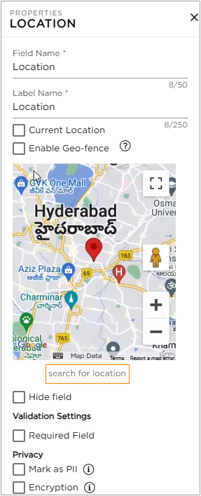
- Field Name: Provide a unique name for the field, which is visible to Citizen Developers (CDs) during app configuration. This name is also used internally in scripts, workflows, and integrations, so it should be clear and consistent.
- Label Name: Provide a unique name for the field which will be visible for the end-users.
- Current Location: Enabling this setting automatically captures the user’s current geolocation using device or browser permissions. Ideal for check-ins, field reporting, and mobile applications.
- Enable Geo-fence: Activates Geofencing functionality, allowing admins to define a virtual boundary around a specific location. Actions can be triggered based on entry/exit from the geofence. (Requires separate geofencing configuration.)
- Select Default Location: Allows CDs to search and select a specific location that will be centered or displayed when the form or application loads. Useful for region-specific operations or guiding users to a known point of interest.
- Hide Field: Hides the field from being viewed in the user interface.
¶ Validation Settings
Required Field: Ensures that users provide necessary information in the field, preventing missing or incomplete data.
¶ Privacy
- Mark as PII: Flags the field as Personally Identifiable Information to help protect sensitive data. This tag carries over to reports, views, emails, and integrations, where alerts help prevent accidental exposure.
- Encryption: Enable encryption to secure the field’s data. Once turned on, this cannot be reversed.
¶ Field Themes
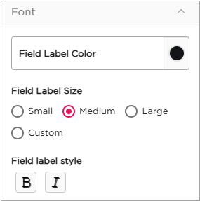
Font Properties
- Field Label Color: Choose or modify the color of the label name.
- Field Label Size: Select the label size: Small, Medium, Large, or Custom.
- Field Label Style: Apply styles such as Bold or Italic to the label name.